Sunday, March 19, 2006

Navigation Nightmare!

Ive got some new mapping software. Superb value. All Ordnance Survey Landranger maps of each of the 13 UK National Parks for just £20! One of the features is to estimate the time it will take to walk a given route. It does this by applying various walk rates depending on whether the ground is flat, uphill or downhill to the type of ground being walked. It supplies some numbers as a start point but you are supposed to time measured distance on flat, up and downhill to calibrate the system. So I went over to Derbyshire and did a good walk up Winn Hill from Yorkshire Bridge. Steep incline, steep descent and a flat walk around the Ladybower Resevoire.

What a disaster!!!!

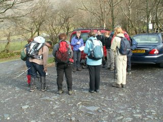
To start with, I got the wrong start point. I got onto the right road OK, and found this


The Yorkshire Bridge Inn. Kitted up off I went - on the north facing track and then west through the wood to the hill summit. Hmm No wood and no easily acessible hill!! After half an hour trotting up and down the track I decided something had gone wrong! The Yorkshire Bridge wasnt the name of a pub.... it was the name of ..... a bridge!

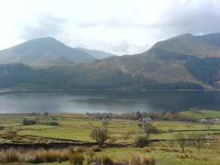
This is the view from it!!

So... North up the track then west.... no problem. No problem at all unless you just look up and down the track, spot a westerly track up the hill and take it.... only to find you went south down the track initially rather than north.

So a ridiculously steep 1km to the summit, turned into a gentle(ish) stroll. Almost an hour and a half later and I reached an unexpected wood! So I turned back and tried to get a bearing, figured out what had gone wrong and got myself back on course. Didnt help with my timings though!

Reached the summit - here is the obligatory photograph at the trig point...

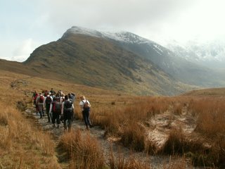
Some views en route.....


Thats LadyBower resevoir in the background


Thats the hill I went up.

So I got myself down OK and then needed some timings on the flat. Checked my notes. Walk about 15 mins should get to a stream. Check. Walk 10 mins should get to a bridge. Check. I was a bit surprised to find myself almost back to the bridge about 90 mins early! The features I reached were obviously not the ones I was expecting, but different ones further along the route.

So all in all from a navigation perspective it was a disaster! Oh well - its all a learning experience.

Next week is rest weekend but the weekend after I will be tackling Derbyshire's highest peak on Kinder Scout with the evil Jacobs Ladder ascent!

Monday, March 13, 2006

Snowdon

Just back from the first of my "big 3" mountains in the UK - Snowdon.
It was an organised training weekend with some people going to Peru, some to Killamanjaro and 3 of us going to Base Camp (albeit at different times). The hostel was comfortable, if basic (and expensive for what it was - wouldnt recommend it from a value for money perspective (www.snowdonlodge.co.uk). Apparently Lord Tennyson was born there!

After a nightmare journey there taking over 6 hours (couple of accidents en-route blocked the roads) we arrived at about 11pm on Friday night just in time for bed!

There are 6 trails up to the summit, and ourleaders, Riana and Richard took us up the Ranger Track on Saturday. Weather was touch and go, but we all decided we would prefer to risk not reaching the summit than take the other option which was to climb a smaller mountain with a peak below the 800m snowline.


Kit checked, and ready for off.


Got a new phone with a better camera. That will be 3 that I'll be taking with me now! Hopefully one of them will function OK while Im away.


Not bad for a camera phone! Absolutely stunning scenary en-route to the top.

reached the snowline at about 800m - time to put an extra layer of clothing on ... and a wooly hat!


Lunchtime at the top. Where did all those people come from?!!

And thats another summit in the bag! I need to adjust my gym work I think. Im really finding it quite difficult to climb the very steep sections of these walks. I always get there, but much slower than I think I should. I'll have to speak to Lana and see what we can sort out.

Sunday morning started with some theory - Navigation Skills, Safety and Security, Top Tips and you will have to trust me that these are hand drawn weather maps to explain how weather works and how to spot looming problems!


The forecast of very heavy snow on the way home persuaded us to skip the planned short walk in Betws-y-coed in favour of a shopping trip to the abundance of outdoor shops there and a lunchtime return home.

All in all a worthwhile trip with some breathtaking scenary and harsh conditions to test us.

Monday, March 06, 2006

Burbage Rocks - Dark Peak; Derbyshire

Had a day in the Peak District yesterday with my (sometimes reluctant!) walking partner!


It was a grade 2 walk of about 5 miles but having to gee up a un motivated 12 year old daughter made it feel much tougher :)

Got the car stuck in snow in the Longshaw Car Park (Thanks to the nice man who kindly helped me out!)

Nice day out. Next week it's the first of the country's big 3... Snowdon!